Google Maps (aus Wiki)
Gehört zu: Landkarten
Siehe auch: Google, Navigation, Google Earth
Stand: 14. Juli 2021
Eine Google-Anwendung, die mit dem WebBrowser Landkarten und Routen (Navigation) anzeigt.
— Dkracht 12:29, 6 December 2009 (CET)
Gehört zu: Landkarten
Siehe auch: Google, Navigation, Google Earth
Stand: 14. Juli 2021
Eine Google-Anwendung, die mit dem WebBrowser Landkarten und Routen (Navigation) anzeigt.
— Dkracht 12:29, 6 December 2009 (CET)
Gehört zu: Geografie
Siehe auch: GPS-Logging, Geo-Tagging, GPS-Nagivation, AMOD AGL3080, Garmin Colorado
Siehe auch: Zeitmessung, Urlaub
Stand: 28.4.2020
For Garmin only: https://www.javawa.nl/gmtk_en.html
Das Global Positioning System GPS besteht aus einem Netz von Erdsatelliten in ca. 12-stündigen Umlaufbahnen. Jeder Satellit hat eine/mehre Atomuhren an Bord.
1978 Start des ersten Satelliten für den Aufbau des GPS.
Gerade das GPS-System liefert heute ein Argument dafür, die Schaltsekunden aufzugeben und die reine Atomzeit (TAI) als Weltzeit zu definieren: Bei der notwendigen sorgfältigen Synchronisation der GPS-Satelliten wurden die Schaltsekunden nicht berücksichtigt. Seit Einführung von GPS im Jahr 1980 hat sich die Differenz zwischen der internen GPS-Zeit und der offiziellen Weltzeit UTC auf 13 Sekunden aufsummiert. Eine versehentliche Verwechslung der Zeiten, etwa bei der Navigation von Flugzeugen, könnte zu Katastrophen führen.
Die Signale der GPS-Satelliten beruhen auf den Zeitmessungen der an Bord befindlichen Atomuhren (Caesium, Rubidium). Wenn der GPS-Empfänger keine eigene Atomuhr hat, benötigt man die Signallaufzeiten von vier GPS-Satelliten, um den Ort (drei Variable) und die Zeit des GPS-Empfängers zu bestimmen.
Wenn man die Atomuhr an Bord eines Satelliten mit einer Uhr am Boden vergleicht treten relativistische Effekte auf:
Web Link: Clifford M. Will: Einstein’s Relativity and Everyday Life http://www.physicscentral.com/explore/writers/will.cfm
After the launch of the Envisat satellite, measurements of the on board clock from Feb 22 to Feb 26, 2004 showed a “Step Length” of 3.906.249.777 to 3.906.249.778 pico sec (10-12 sec).
Beim GPS-Logging speichert ein kleiner GPS-Empfänger laufend die gemessenen Koordinaten und die Zeit. Dadurch lässt sich ein Bewegungsablauf (die Route) dokumentieren…
Beim Geo-Tagging wird jedes Foto mit den geografischen Daten verknüft. So kann mach solche Fotos dann z.B. mit Google Earth oder Google Maps verknüpfen…
Bei der GPS-Navigation braucht man ein schönes Display auf dem Landkarte und berechnete Route (von A nach B) angezeigt wird…
Beim Geo-Caching soll ein symbolischer Schatz gefunden werden…
ich habe ja ein HTC Touch Diamond, das eine eingebauten GPS-Empfänger haben soll. Ich möchte diese GPS-Funktion mal ausprobieren, ohne das zusätzliche Kosten entstehen; d.h. ich möchete dabei keine Internetverbindung aufbauen z.B. zu Google Maps oder oder oder…
Software:
Damit bekomme ich vor dem Haus auf der Strasse so 6-9 Satelliten.
Unser Urlaub startet in Hamburg…
— Dkracht 15:19, 17 July 2009 (CEST)
Benutzt: Fotos aus Google Drive
7.10.2009 Tag 12 (Weiter: Tag 13 zurück: Tag 11)
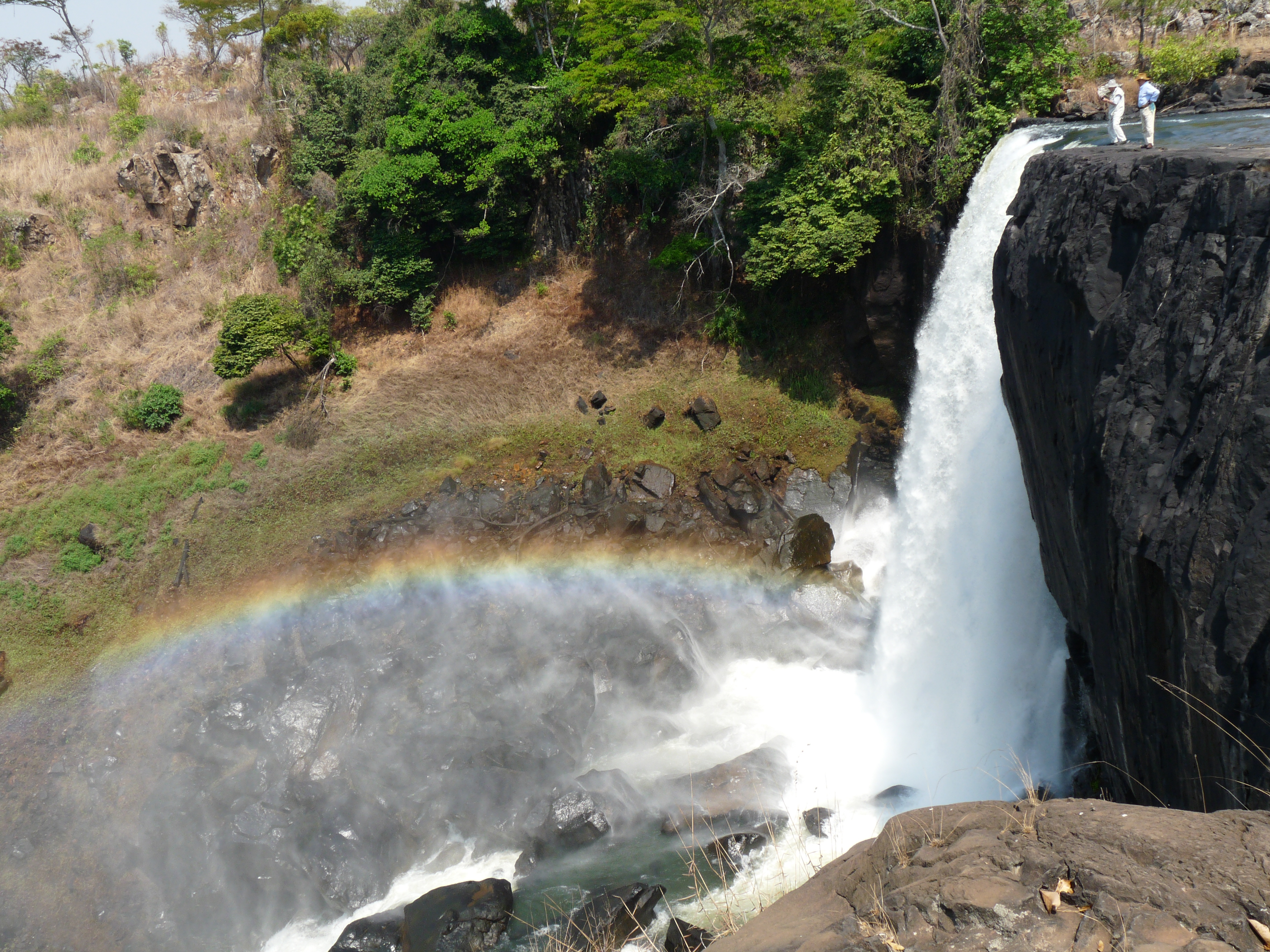
Abbildung 1: Chishimba Falls – Upper Fall (Google Drive: DK_20091007_1080153.JPG)
The Luombe River 7.2 km from Chilubula Mission in Kasama District makes a beautiful water fall called: Chishimba Falls (older: Chisimba Falls). The Luome river joins the Lukulu River shortly after the falls.
Location directions: Drive from Kasama center on the M3 westbound for about 24km, then take the junction to the D20 road. After 11km on the D20 follow the sign “Chishimba Falls 700m – National Monument” to the left. A hydro-electric power plant (owned by ZESCO) is located above the falls.
GPS:
Over a distance of 300m there are three successive falls:
The Chishimba Fall belongs to the Monuments and Historic Sites of Zambia.
Die Software “Amod GPS Tracker” wurde zum meinem GPS Tracker AMOD AGL3080, denn ich für den Urlaub 2009 in Afrika angeschafft hatte, mitgeliefert.
Hat bei ersten Versuchen funktioniert, später aber gab es irgendein Problem und ich bin zu GeoSetter gewechselt…
— Dkracht 17:53, 11 December 2009 (CET)
Viele Geräte, die man in den Urlaub mit nimmt, benötigen elektrischen Strom:
Entweder nimmt man:
Eine klassiche Alkaline-Batterie wird von den Geräten auch nur bis 1 Volt ausgenutzt. Oberhalb von 1 Volt hat sie aber auch maximal nur 2000 mAh.
Gängige NiMH-Akkus haben z.B. 1800 oder 2200 mAh – also auch nicht weniger. Vorteil: wenn die Akkus aufgeladen sind, sind sie wirklich voll. Bei der Batterie weiss man nie genau, wie lange sie noch hält.
Die älteren NiCd-Akkus haben diesen schrecklichen Memory-Effekt. Deshalb solte man nur noch die neueren NiMH-Akkus nehmen.
Hauptproblen bei den NiMHAkkus ist, dass sie sehr empfindlich gegen Überladung sind. Deshalb sollte man entsprechend intelligente Ladegeräte benutzen.
Bei den gten NIMH-Akkus steht ‘drauf, wie hoch maximal der Ladestrom sein darf. z.B.
Das ANSMANN DIGISPEED 4 arbeitet bei Schnellladung mit einem Ladestrom von 1750 mA. Ein 2200 mAh Akku würde dann in 90 Minuten aufgeladen sein.
— Dkracht 23:06, 21 July 2009 (CEST)
Gehört zu: Afrika
Im Urlaub möchte man ja auch etwas über das Land wissen.
The Big Five:
See also: Landkarten
Gehört zu: Reisen Südafrika
See also: Beobachtungsorte mit geringer Lichtverschmutzung, Golfreisen, Google Drive
Benutzt: Fotos von Google Drive
Stand: 23.09.2021
I arrived in Kagga Kamma on Feb 8th, 2016 and stayed there for two nights.
Planned for the first night (Feb 8th – New Moon) was a Stargazing Event, but that was cancelled by Kagga Kamma due to “heavy wind conditions”.
I managed to make some “pretty pictures” with my digital camera (Sony NEX 5R guided by a Nano Tracker) – See separate article on my fotos: https://picasaweb.google.com/104669836391658707391/KaggaKamma2016PrettyPictures?authuser=0&authkey=Gv1sRgCMnw3PLo4ZuQWg&feat=directlink&noredirect=1
Next day (Feb 9th) Kagga Kamma could perform the “Stargazing Event” later in the evening, after dinner in the Boma.
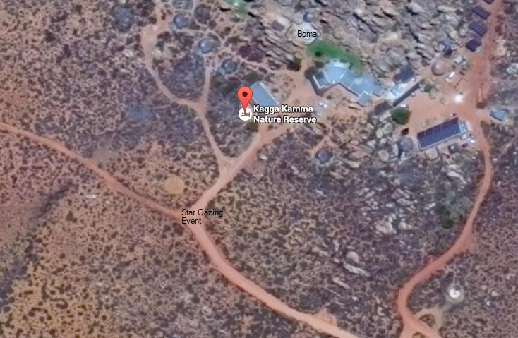
Abbildung 1: Kagga Kamma in Google Maps (Google Drive: KaggaKammaStarGazing.jpg)
Kagga Kamma Star Gazing
Two young rangers did the event some 200 meters from the boma away in a darker place.
The two rangers had a good basic knowledge of astromomy and explained (with laser pointers) how to find the Southern Cross via the “pointer stars” (alpha & beta centauri) and how to determine the celestial south pole and the south point from there.
The first object the two rangers showed in the telescope (Celestron Nexstar 8SE – 203/2032mm ) was Jupiter.
This was very impressive, Jupiter as a disk with cloud stripes and three moons were nicely visible.
From the audience came a question on the magnification of the telescope – the two rangers could not answer that question.
On repeated questions on the magnification and what eypepiece is used, the rangers could find out that the eyepiece was f=5mm.
Magnification can easily be calculated as 2032 / 5 = 406 which is nice for Jupiter, but much too large for other nice Deep Sky Objects (DSOs).
This very large magnification was also the reason for wind problems, as little blows from the wind did cause large shaking in the visible flield of the telescope – when using an eypiece like this (5mm). The wind problem should be much lesser with eyppieces of f=15mm or more…
The second object the two rangers showed in the telescope was Beta Centauri – very interesting: you could really see a single star in the telescope…. could Alpha Centauri as a double star be a better object to show….?
The third object the two rangers offered to see in the telescope was Rigel (Beta Orionis) – again we could see a star in the telescope….
The fourth object the two rangers offered to see in the telescope was Betageuze (Alpha Orionis) – once again one could see a single star in the telescope (eyepiece still 5mm)…
The rangers explained how the constellations Orion and Scorpio are related, but they made no attempt to position the telescope to the famous Orion Nebula (M42).
After that, the two young rangers declared the end of the stargazing event.
After protests from the audience, the rangers made an add-on: they postioned the telescope (as always easily via the GOTO function) onto the Plejades (Six Sisters).
And indeed we now could see a small fraction of the Plejades through the telescope with the 5mm eyepiece – no full, picture of the open star cluster, that would have required a different eyepiece (15mm, 20mm,…).
I personallay asked the two rangers to direct the telescope (via the easy GOTO function) to more interessting objects.
The Kagga Kamma rangers had no idea what “a more interesting object” could be.
I suggested “47 Tuc” (one of the largest and brightest globular star custers in the southern hemisphere) – the Kagga Kamma rangers had no idea, how to find this spectacular object.
Kagga Kamma is a nice place for stargazing in South Africa. The sky is so very much dark in that location. The rangers have a beautiful telescope, a Celestron Nexstar 8SE, but are not really able to show interesting objects in the darkness of the sky in Kagga Kamma which is wonderfull for stargazing in South Africa. Instead the rangers show boring objects i.e. a single star like Betageuze, Rigel or Beta Centauri. The dark sky is a great precondition in Kagga Kamma for overwhelming stargazing, but the rangers do not leverage this great opportunity to show amazing celestial objects like e.g. globular custers with the Celestron Nexstar 8SE for stargazing in the southern skies. As a bottom line my visist to Kagga Kamma was disappointing.
Gehört zu: Afrika
Was haben wir alles an Tieren gesehen:
Gehört zu: Afrika
Siehe auch: Rovos Rail, Google Fotos
Benutzt: Fotos von Google Drive
Stand: 27.11.2021
Der Marula-Baum, auch Elephant Tree genannt:
Abbildung 1: Marula-Baum (Google Drive: marula021.jpg)
Marula Tree (Copyright Wikipedia)
Abbildung 2: Jacaranda Tree (Google Drive: starr_010419-0078_jacaranda_mimosifolia1.jpg)
Jacaranda Tree – Copyright Wikipedia Commons
Abbildung 3: Baobob Tree (Google Drive: SenegalBaobab.jpg)
Senegal Baobab Tree – Copyright Wikipedia Commons